The 981 Project Podcast Podcast Por Tamela Rich arte de portada

The 981 Project Podcast

The 981 Project Podcast

De: Tamela Rich
Escúchala gratis

Obtén 3 meses por US$0.99 al mes + $20 crédito Audible

Join Tamela Rich for dispatches from all 981 miles of the Ohio River: people, places, history, culture, and more.

the981project.comTamela Rich
Ciencias Sociales Escritos y Comentarios sobre Viajes Mundial
Episodios
  • How did a 1937 Flood Became the Blueprint for Food Banks?
    Nov 13 2025
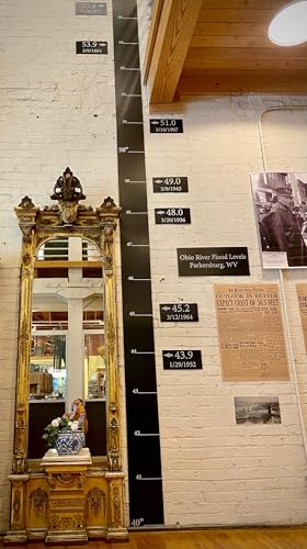
    This is Part One of “Flood to Food Banks,” a three-part exploration of how the Ohio River became America’s testing ground for social uplift.With American hunger back in the national headlines, I’ve been thinking about how this story of hunger relief began. I was surprised to learn it wasn’t with pantries and food drives, but with the Ohio River’s most devastating flood at the start of Franklin Delano Roosevelt’s second term. My own research on the topic started several years ago, when I visited the Blennerhassett Museum of Regional History in Parkersburg, West Virginia, during the summer of 2021. However, at the time, I wasn’t looking for the origins of the modern food bank system—I hadn’t even thought about it. It was just part of my general reconnaissance of the region and its many historical facets.I bought an admission ticket and stepped into the first-floor gallery, where a black gauge climbs the white brick wall, ending past the landing of the second story balcony. It was like a ruler of reckoning showing flood levels from 1884, through 1964. If you look at the picture below, the scale begins at forty feet, because that’s the elevation of the museum floor above the river’s normal height. I tilted my head up, then back a little farther, squinting to see the highest line of its record crest: 55.4 feet, January 26, 1937. The number is tidy, and the mark is exact, but the mind resists it without context, so here’s mine. At five-foot-one, I calculated it would take nearly eleven of me stacked head to toe to reach 55.4 feet. And yes, if you look closely in the mirror beside the gauge, you can see me in the reflection—small against a wall that once marked catastrophe.Now, imagine the whole town underwater to understand what fifty-five feet really means in human terms. What began here as an act of rescue in 1937—feeding, housing, and clothing the displaced—would teach government and charity alike how to manage hunger, and other human needs, long after the waters receded. Even before the river crested, the Red Cross was on the ground, issuing rations and setting up shelters in churches and schools. When the flood reached its peak, President Roosevelt declared a national emergency—one of the first in response to a natural disaster—and released ten million dollars for relief. In today’s dollars, we’re talking $220 – $250 million. His order unlocked every corner of the New Deal: Works Progress Administration crews (WPA), Civilian Conservation Corps (CCC), the Army Corps of Engineers, and the Red Cross all moving in a single rhythm. Harry Hopkins, Roosevelt’s trusted advisor and briefly his Secretary of Commerce, oversaw the WPA’s seven divisions, from heavy construction to public service, education, and the women’s sewing and nursing projects that reached into every county. The WPA had begun as a jobs program employing more than 8.5 million people for an average monthly salary of about $41. Under Hopkins, the seven divisions moved as one—not only repairing infrastructure, but also delivering food, sewing blankets, and keeping disease at bay. Within a week of the crest, field kitchens were serving thousands of meals a day—a wartime scale of feeding in a peacetime disaster. The flood proved that compassion, when well organized, could act on a scale it had never attempted in peacetime.Back at my tour of the Blennerhassat Museum, I walked into another exhibit hall featuring a wooden skiff resting beneath a photograph of a long-ago packet boat. It’s small, flat-bottomed, and open to the air—the kind of boat that Parkersburg’s police and firemen rowed to deliver food and evacuate families, scraping across flooded porches and telephone wires along the way. For weeks, the city was an archipelago of rooftops and rescue routes, as were sister cities for all 981 miles of the river. But police and fire crews weren’t the only ones rowing skiffs. Younger men from the Civilian Conservation Corps were pulled from their usual duties—planting trees, building bridges, and breaking the ground—literally—on the Blue Ridge Parkway. My grandfather was a “CC man,” as they called themselves, but wasn’t serving at the time of the flood. Had he been, he would have rowed a skiff through flooded streets, delivering food and medicine, and disinfecting the mud with lime and kerosene to prevent disease—plus anything else the relief effort required of him.So yes, before America could build a system to feed its hungry, it had to learn how to feed its stranded. The Ohio River flood didn’t just reshape levees and zoning maps—it rewired the nation’s sense of how care could be organized.By the spring of 1937, the Ohio was back in its banks, but the idea it unleashed kept flowing east. Relief workers and engineers carried their notebooks to Pittsburgh, where federal and local leaders began asking a new question: could the same system that fed the stranded be adapted to...
    Más Menos
    9 m
  • Kentucky Trivia: The Birth of a State
    Oct 21 2025
    I don’t mind embracing my age, so I’ll confess to watching The Daniel Boone TV show (1964–1970). I can even sing the theme song. If you’re a youngster, you may have seen it on cable reruns: Boone as the all-around good guy and frontier hero, conducting surveys and expeditions around Boonesborough, running into both friendly and hostile Indians, before, during, and even after the Revolutionary War. Of course, there’s the TV Boone and the historical one—the Boone who symbolized Virginia’s land policies more than he shaped them himself.Multiple states claim Daniel Boone because of his travels across the frontier — Pennsylvania, where he was born; North Carolina, where he came of age; Kentucky, where he blazed the Wilderness Road and helped open the interior to settlers; and Missouri, where he lived out his final years.Today, our focus is Kentucky: how Boone’s surveying and trail-blazing symbolized Virginia’s land policies, and how those policies paved the way for statehood in 1792.The explanation begins in1609 when King James I granted the Virginia colony a charter that stretched “from sea to sea,” sweeping aside the French, the Spanish, and of course the Indigenous nations already here. During the Revolution, Virginia organized Kentucky County (VA), and by the 1780s it was further divided into Fayette, Jefferson, and Lincoln Counties. Together these counties formed a distinct bloc that petitioned Congress for separation from Virginia again and again. With over 70,000 settlers by 1790, Kentucky had the numbers and leverage to become a state in 1792 and added the counties of Nelson, Bourbon, Madison, Mercer, Mason, and Woodford. For comparison, Ohio didn’t qualify for statehood until 1802, and that was through an exception called The Enabling Act.“Wasted Land”The Virginians of 1790 often described Kentucky as “wasted land,” which is not a legal term. “Waste” in property law usually referred to land not in active agricultural use (unfenced, uncleared, unplowed). Colonists and early legislators often borrowed this language to justify dispossession.Today, we can appreciate that just because the land wasn’t managed with European methods doesn’t mean it was not being managed at all. For centuries, Shawnee, Cherokee, Mingo, and other nations had hunted, farmed, and burned the forest here. They moved seasonally between river bottoms and uplands, and their claims overlapped, making Kentucky one of the most contested landscapes in eastern North America.Virginia dismissed this history and parceled Kentucky out as if it were empty. This language laid the groundwork for legislation like Virginia’s Land Law of 1779, which opened “unpatented lands” in the Kentucky district to Revolutionary War veterans of the Virginia Line, through bounty warrants. This swath of land is the Military District of Kentucky, shown in gray on the map below. Many veterans never came — selling their warrants to speculators — but the district shaped settlement patterns all the same.The Land Law also legalized settlers’ preemption claims—squatters’ rights that gave anyone who had already built a cabin or cleared fields the first chance to buy land.Encouraged by these policies, thousands funneled through the Cumberland Gap along Daniel Boone’s Wilderness Road, transforming the region within a generation.The Dodgy Deal Behind Boone’s RoadBoone became the symbolic scout, but in reality he was on the payroll of the Transylvania Company, a massive speculative land venture of dubious legality. In 1775 its founder, Richard Henderson, tried to buy twenty million acres directly from the Cherokee at Sycamore Shoals, paying with trade goods. Boone, then living in North Carolina, was hired to blaze the Wilderness Road and help build Fort Boonesborough to anchor the claim.But the Royal Proclamation of 1763 forbade private purchases of Indian land, and both Virginia and North Carolina dismissed Henderson’s colony as a usurpation of their authority (the treaty at Sycamore Shoals took place on land that was then part of North Carolina). Congress also refused to recognize it. Virginia eventually voided the purchase, though it granted Henderson and his partners 200,000 acres in Kentucky as a consolation prize, while North Carolina compensated them with land in present-day Tennessee.It was an audacious bit of what people used to call “frontier lawyering”—an illegal land grab dressed up as a colony whose backers walked away with hundreds of thousands of acres. Henderson wasn’t just any dreamer and schemer—he was a North Carolina judge, with the connections and confidence to push further than most men would dare. And if the playbook looks familiar, that’s because versions of it are still making headlines today.Transylvania collapsed as a colony, but Boone wasn’t a shareholder or speculator — he was the hired scout. When Virginia voided the Transylvania Company’s deal, Boone lost ...
    Más Menos
    27 m
  • A Week Along the Ohio
    Oct 7 2025
    I rode my motorcycle to Athens, Ohio, for a BMW Riders Association rally over the Labor Day weekend. Some of my non-riding friends assume rallies are always boozy events with wet T-shirt contests, but rallies are as diverse as the people who sponsor and attend them. The quieter variety just doesn’t make the headlines. The BMW rallies I attend feel more like family reunions—the chance to connect with like-minded friends and swap stories about destinations, roads, motorcycle mishaps, and everything except politics and religion. Honestly, I can’t tell you what most of my riding friends do (or did) for their livelihoods. We’re too busy enjoying the one thing we have in common: a deep love of motorcycles and the road. Many rallygoers camp on the grounds, which adds to the sense of community—and sometimes the humor. Case in point: this sign I spotted. If you don’t see the unintended humor, give it a minute.I extended my time in Southeastern Ohio for another week so I could do deep research for the book I’m writing for the University of Illinois Press, tentatively titled, Along the Ohio: Stories the River Still Holds. While in Marietta—a river city that was the first settlement in the Northwest Territory—I learned that one of the most respected makers of historical markers is headquartered there. This is the kind of serendipity that makes my pulse race. Please treat yourself to this video about Sewah Studios, which includes scenes from each phase of the manufacturing process. I’ve watched it a couple of times now.Evolution of a Late-Blooming History BuffI didn’t study history in college, mostly because I wasn’t cut out for teaching (which is what I thought the field would necessarily lead to). Besides, my parents weren’t about to bankroll a degree without a solid career plan, so I majored in business. What’s funny is that the part of business that has always fascinated me is its role in cultural history. But that’s a story for another day.Motorcycle travel became my history professor. Out on the road, I’ve picked up lessons in geology and paleontology (Wyoming is top-notch in that department), along with human and cultural history, and plenty of “what-happened-right-here” lessons. Despite my history education being scattershot—it’s more like postcards than a sequenced curriculum—those fragments taught me to look harder at what’s missing, as well as what’s been preserved in public memorials and commemorations.Side note: my kids will someday have the joy of sorting through the 1,000+ postcards I’ve collected on my travels. I’m not doing Swedish Death Cleaning on that collection.I spent the better part of a day in Special Collections at Marietta College poring over brittle papers and pamphlets from 100+ years ago, and it occurred to me that the wording on some of the historical markers didn’t line up with what I was reading. So which version should we believe—the plaques or the papers? You’d think the archives would settle it, but there’s a counterargument to sticking with what’s held in any one collection. After all, history is collected in many different places, and hauled across rivers and seas by descendants of those who lived it.Think about it: history isn’t set in stone. New stories—and new information about old ones—surface all the time: in journals used as insulation for an old home, in the margins of a family Bible, in overlooked archives. Women’s lives are often missing from “the record,” as are the histories of marginalized and ostracized people. I’m enamored with discovering new angles on old stories I thought I knew—the narratives erased or ignored because they didn’t matter to those entrusted with recording the news at the time. When I asked the Special Collections librarian what it takes to get a marker approved, she gave me a wry smile. “Anyone can put up a sign on their property and call it a historical marker”—distinguishing between informal commemorations and the formal program. She continued, “But if you want the official emblem, or to be included in recognized history trails, you have to apply to the sponsoring organization.” She went on to explain that Ohio’s formal system—with the Ohio History Connection’s emblem and inclusion on official trails or registries—is distinct from whatever individuals might erect on their own property. In other words, there is an “official” class of markers in Ohio, and acceptance into the state program is what makes the difference. Still, this doesn’t ensure an error-free or fulsome accounting of the historical place or event being marked.Sometimes local history projects—whether a roadside plaque, a county museum, or a “heritage tourism” trail—are there to reassure the hometown crowd of their historical importance, or to entice visitors to come and spend a little money. They elevate local heroes, polish away contradictions, and speak in absolutes—”...
    Más Menos
    15 m
Todavía no hay opiniones